
*Updated post following the collapse in March 2016 of ‘Elephant Rock’*
If you’re thinking of visiting coastal New Brunswick anytime soon, I have one piece of advice for you: plan on visiting these must-see places near the Bay of Fundy at least twice. Here’s why.
New Brunswick’s coastal sights really need more than one visit to see them properly, not just because you want to be sure that maritime weather works in your favour, but because the Bay of Fundy has the world’s highest tides (yes, Canada holds that proud title for the planet!). To see just how dramatic these tides are, you’ll want to see every must-see location at both low AND high tides, in order to appreciate the full effect of 40+ feet of ocean coming and going. Short of a tsunami, which I would hope none of us have to experience, this is one pretty awesome force of nature.
Take Hopewell Rocks, for example.
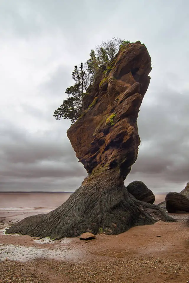
The Tourism board certainly adopted the right sound bite with their ‘Walk on the Ocean Floor’ slogan, because with a drop in tides of over 40 feet, exploring the base of Hopewell Cape’s famous Flowerpot Rocks is much more than a typical stroll on the beach. We timed our visit for one of the highest tides in the month (leaving that to Copernicus – aka Henk – and his orbital calculations of the moon’s proximity, time of year and park opening hours), which resulted in our seeing some of the most dramatic changes to the land and waterscape.
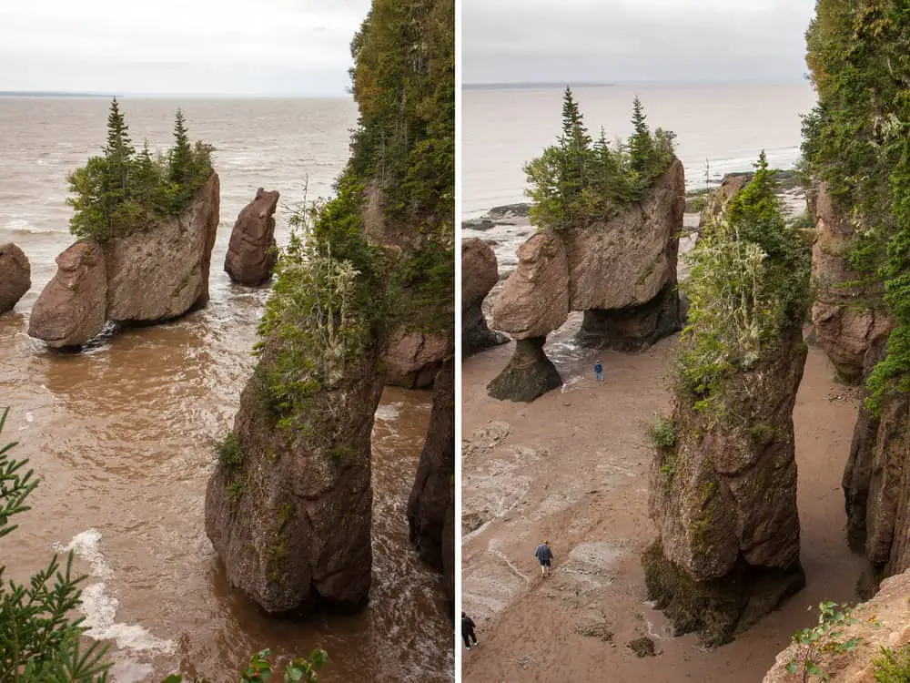
High Tide vs Low Tide at Hopewell (check out the people for scale)
Changes are the name of the game at Hopewell Rock, as witnessed only recently with a collapse in March of 2106 of one of the most recognized rock formations known as ‘Elephant Rock’. Having stood for decades, the sculpted ‘canyon’ between these two rock pillars is now a tumble of giant boulders. We were there before the collapse, walking between those huge monoliths!
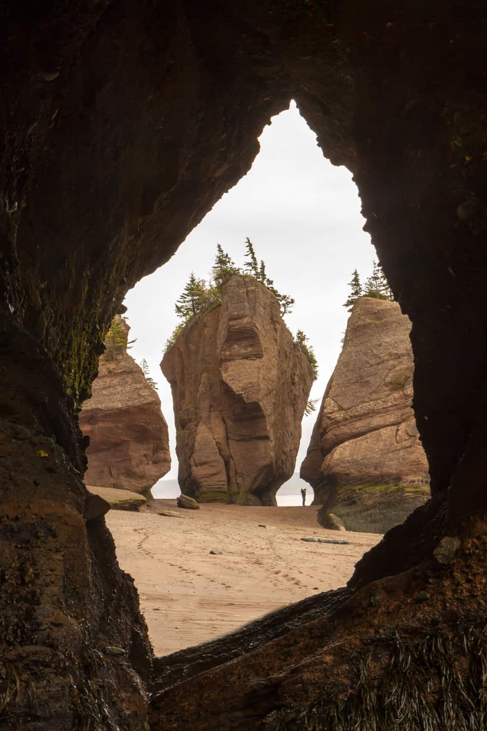
Beachcombing where water has carved sculptures out of the rock. (Photo taken in 2013 during our visit)
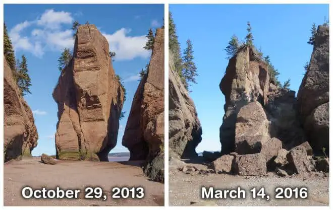
In March 2016, ‘Elephant Rock’ collapsed, demonstrating once again the ever-changing force of Nature.
Walk on the ocean floor.
Low tide meant we could walk for hours along the shore, exploring the bases of water-carved rock sculptures, cove after cove following the coastline, with the exposed ‘beach’ stretching far out from shore. Returning to the same beach several hours later, we were amazed to see formerly dry land where we had beachcombed only hours before, now transformed into an ocean swell battering the cliffs.
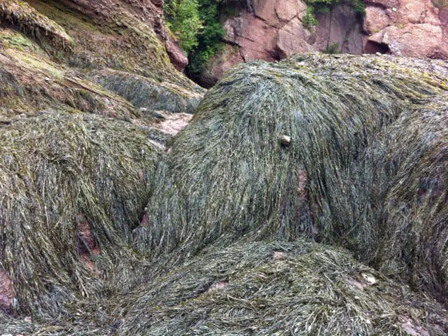
Seaweed anchored to exposed rocks reminded me of a woolly mammoth.
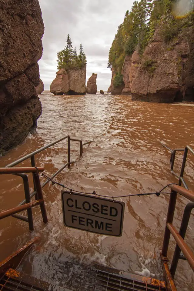
Stairs we used to access the beach were immersed below us as the tide crashed into the crevices between the famous flowerpot islands, now submerged up to their ‘necks’.
It became clear why the park built an escape platform at the furthest end of the long beach – a secure position from which you could wait out the high tide, should you find yourself trapped in the cove by the rising waters. But not to worry – this isn’t a tsunami, and the park staff round up the strays in plenty of time to make it off the beach.
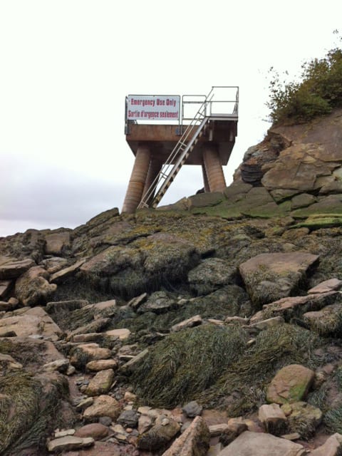
The ‘sit-it-out-and-wait-for-low-tide’ option if you stray too far, for too long.
Alma’s Wharf
Here’s another example of why you must see every destination twice: the pier in this tiny town of Alma at the entrance to Bay of Fundy Provincial Park would be just another fishing wharf, if you only saw it at high tide. But come here when the water is not just low, but GONE, with no sign of ocean for a kilometer or so out from shore, and you’ll be surprised to see boats resting on mud.
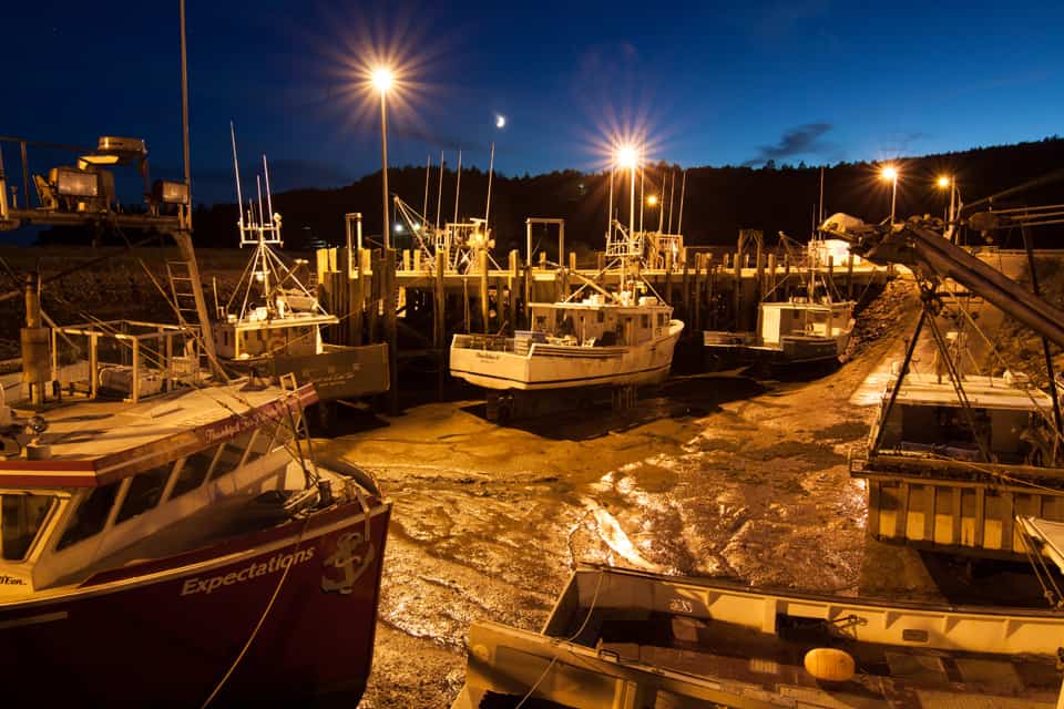
Alma’s wharf midnight, low tide
What looks like a drydock shipyard is a functioning wharf when the tide is in, but when it’s out, the boats need to be kept upright with a kind of sawhorse affair that is placed under their hulls to keep them from tipping over. Who knew?
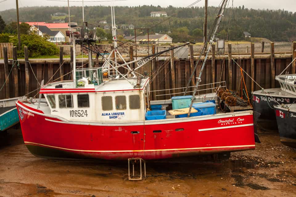
Alma by day, low tide
Bass-ackwards at the Tidal Bore, Moncton
It’s 3:42am and the alarm goes off in our hotel room, and not by mistake. This is the time that the ‘tidal bore’ (a meter-high tidal wave flowing upriver) is expected to arrive at this point on the Petitcodiac river in Moncton – located literally steps from the doors of our hotel situated on the river’s north bank. The wee hours of the morning meant our timing was less than perfect for photos, but that’s what happens when you are at the mercy of Mother Nature.
This cyclical inflow of the tide used to be quite the bore here, literally, after a causeway was built further downstream that acted as a dam for the inflowing tide. But now that the causeway gates have been opened to allow the natural flow of water, surfers have actually made Moncton a cool destination to ‘catch the wave’ as the cresting tide rolls 29 km or so into Moncton.
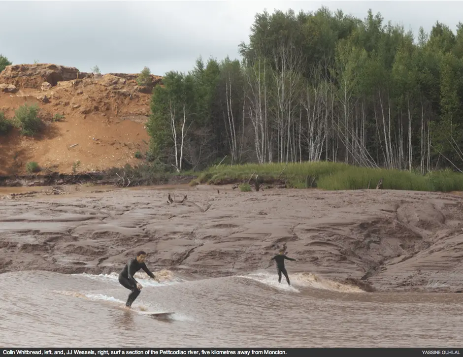
Not exactly my cup of tea, surfing upstream on a ‘chocolate river’, but for some of the younger mudpuppies who want to hang ten out there, this could be quite the destination. You can check out a video here.
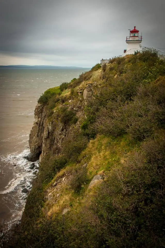
Cape Enrage!!!!
This name seems to come right out of a Stephen King novel, as does the setting, a jagged spear of land jutting out into the entrance to the Bay of Fundy, which, depending on the weather, can appear almost sinister. We happened to be there on a windswept afternoon when the clouds were low, and the weather ominous, making the solitary lighthouse perched on its cliff even more lonely a sentinel.
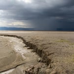
The next day, again following the tide’s lead, we returned for low tide, curious to see how the landscape had changed, now that the rocky shoreline was exposed. Even with the early morning appearance of a thick fog, we could see the danger evident in the exposed black rocks extending far out into the bay below the lighthouse cliff. In fact, with the fog horn sounding its melancholy warning it became obvious why this point of land had been named for the angry threat it posed to passing ships.
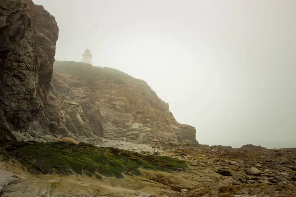
Cape Enrage from below, tide out, fog in
And while the fog kept us from seeing the full extent of this shipwrecking reef, it did provide an evocative backdrop for shooting this portrait of Henk (apparently the trick to achieving such a heroic photo is shooting from a low point of view, and giving Henk a large stick.)
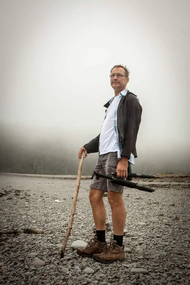
Heroic Henk
Weather aside (this IS the maritimes after all), my first impression of the Bay of Fundy was a good one. Being a landlubber all my life, where the only bodies of water I grew up with are landlocked lakes, the tidal cycles that influence not just the landscape here, but the lives of its residents, took a little getting used to. The scenery, on the other hand, had me at hello.
TIP: Plan to visit all of the noteworthy Bay of Fundy sights twice. I know I said this at the beginning of this post, but this particular tip, like the sights themselves, bears repeating. Fortunately, many of the parks’ entrance tickets are good for two days to help accommodate this.

Jane Canapini is a member of the Travel Media Association of Canada and the North American Travel Journalists Association. She established GrownupTravels.com in 2014 to share information and tips based on personal experience so her readers could get the most out of their travels.


")

")


Great photos! Nature is amazing. I would love to see the Bay of Fundy at high tide and low tide. Twice at least!!
Twice is definitely the way to go, Irene. You can even check the tide schedules online, so you know if Hopewell Cape park will be open at both high and low tide. (even if it isn’t, you can still walk down to the shoreline)
Fundy looks like a wonderful place for a photographer. Another one for my Canadian bucket list!
It definitely is a photography destination, even with the recent rockfall. (Just a testament to the ever-changing power of Mother Nature.) Just allow time to see it both at high and low tides.
The Bay of Fundy is so cool. We could actually see the tide coming in and out. Didn’t know they surf on it though. Guess it makes sense.
I think some people will find a sport in anything, even tidal bore surfing! 🙂
Looks incredible and those tides!! I used to live in SE Alaska where there were 13 foot tides and we thought we had it rough. Great post. I hope to see this myself one day.
It was something that I really wanted to see, too, since the Bay of Fundy tides are once of the world’s wonders. So glad we saw it before some of it crumbled.
Beautiful pictures. I’ve never been to Canada’s east coast (I know! I’m Canadian) and seeing that I love photography, I know I’d love going to the Bay of Fundy. What a shame about the collapse of the rock formation in Hopewell Cape.
It just goes to show you that Nature is never static, I guess. But it was still a little sad to see something crumble that we had seen only for the first time a couple of years ago.